sphenix-run-l AT lists.bnl.gov
Subject: Commissioning and running of sPHENIX
List archive
- From: "Huang, Jin" <jhuang AT bnl.gov>
- To: "sphenix-run-l AT lists.bnl.gov" <sphenix-run-l AT lists.bnl.gov>
- Subject: [[Sphenix-run-l] ] Fw: Weekend weather
- Date: Fri, 14 Feb 2025 17:44:50 +0000
Sent: Friday, February 14, 2025 12:34 PM
To: CAD Personnel List <allcad AT bnl.gov>; Physics Personnel <PhysicsPersonnel AT bnl.gov>; IP Personnel List <IPPersonnelList AT bnl.gov>; EIC Directorate <EICDirectorate AT bnl.gov>
Subject: Fw: Weekend weather
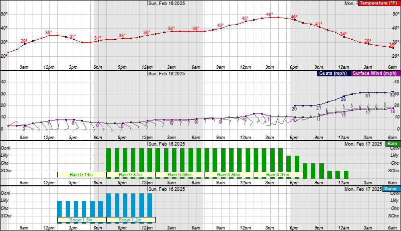
Summary: The NWS as of 9:54am is predicting Snow to start around 1pm Saturday with accumulation of 2.7” before changing over to rain and ending Sunday night. Sunday temperature rising to 49 degrees.
Saturday
Snow likely after 1pm. a high near 35, Light and variable wind becoming south 5 to 8 mph in the morning. Chance of precipitation is 70%. New snow accumulation of 1 to 2 inches possible.
Saturday Night
Rain and snow, becoming all rain after 1am. Temperature rising to around 38 by 3am. East wind 5 to 8 mph. Chance of precipitation is 100%. New snow accumulation of 1 to 2 inches possible.
Sunday
Rain before 1pm, then showers, mainly after 1pm. High near 49. East wind 9 to 13 mph becoming south in the afternoon. Chance of precipitation is 100%. New precipitation amounts between 1 and 2 inches possible.
Sunday Night
Showers likely, mainly before 7pm. Mostly cloudy, with a low around 24. Chance of precipitation is 60%. New precipitation amounts of less than a tenth of an inch possible.
William Hulse Jr.
Manager-Office of Emergency Management
Brookhaven National Laboratory
Ph: 631-344-5758
Cell: 631-871-8018

- [[Sphenix-run-l] ] Fw: Weekend weather, Huang, Jin, 02/14/2025
Archive powered by MHonArc 2.6.24.